THE DEFINITIVE GUIDE TO
Drone 3D Modeling Deliverables
for Southern Utah Construction
In the rapid expansion of the Cedar City and St. George corridors, data has become the most valuable asset on a construction site. As projects grow in complexity and schedules tighten, the margin for error shrinks. For general contractors, developers, and earthwork specialists, moving from estimating site progress to measuring it is what separates a profitable project from a budget overrun.
Southern Utah construction poses unique challenges that traditional site management tools often struggle to address. The combination of abrasive volcanic rock, massive elevation shifts, and the blistering pace of multi-phase subdivision growth requires a level of oversight that ground-based teams simply cannot provide manually.
Understanding the Big Three deliverables — Orthomosaic Maps, 3D Surface Models, and Progress Documentation — is essential for any stakeholder looking to protect their bottom line.
 BlueCrest Aerial
What Drone Mapping Actually Produces
The most fundamental deliverable in drone mapping is the orthomosaic. To the untrained eye it looks like a standard aerial photo. In reality, it is a complex data product — a geometrically corrected map stitched together from hundreds or even thousands of individual overlapping images. Standard photos have perspective distortion where objects at the edges lean outward and distances are skewed. An orthomosaic removes this distortion so that every pixel represents a precise point on the ground, making it a spatially accurate tool for measurement and planning.
Plan Overlays and Error Detection
The primary ROI of an orthomosaic is the ability to perform plan overlays. In Southern Utah, where terrain can be unpredictable, ensuring that work on the ground matches the civil engineering designs is critical. By taking CAD files or blueprints and overlaying them on the live orthomosaic, a Project Manager can visually confirm that foundation walls, utility trenches, or curb lines are being placed exactly where they belong.
Catching a two-foot deviation in a utility trench before the pipe is laid and the trench is backfilled can save thousands of dollars in rework and prevent a cascade of scheduling delays.
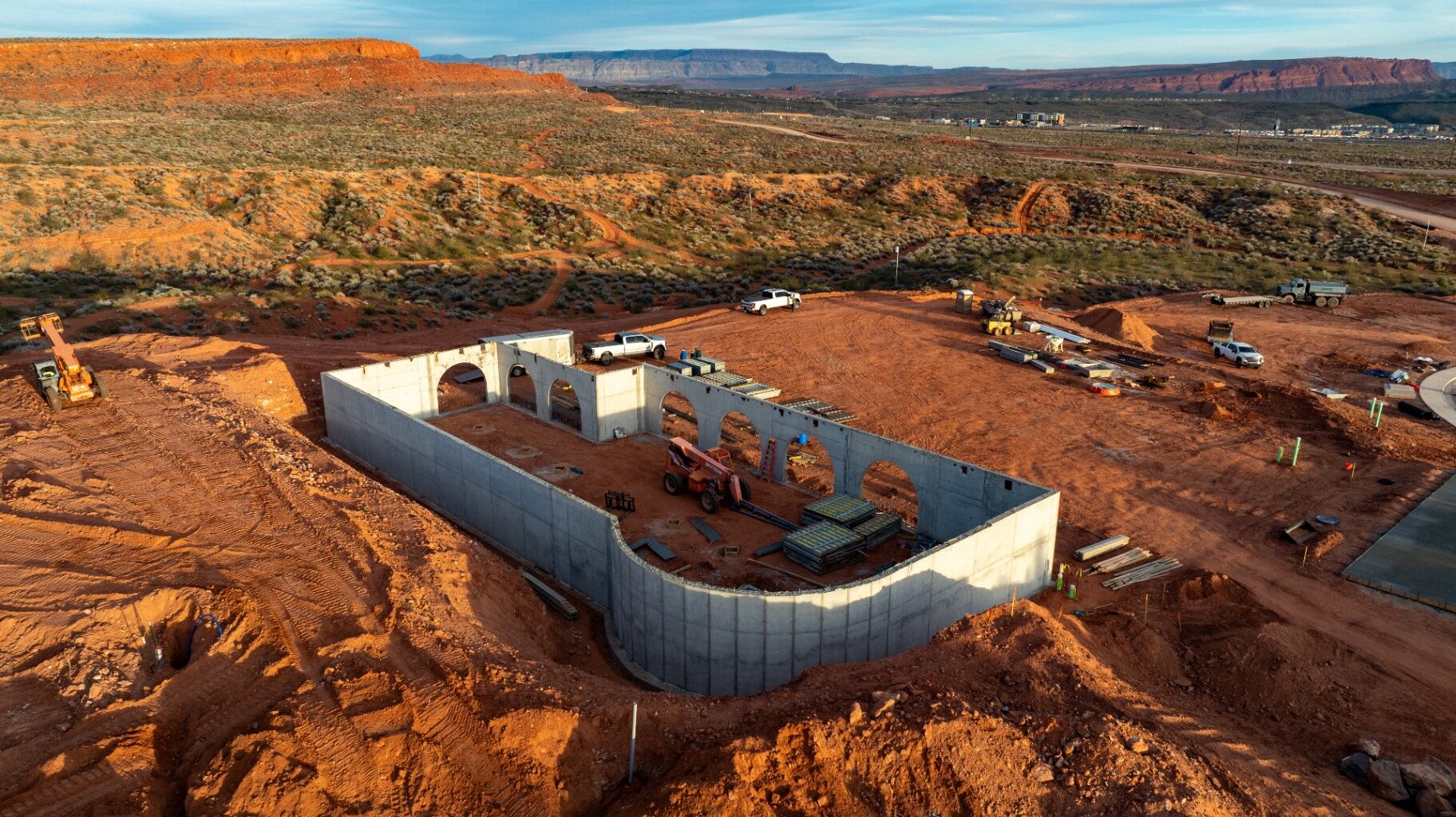
As-Built Documentation
Construction is a series of layers. Once a layer is covered — whether a utility line buried in a trench or a foundation footer covered by a slab — it becomes a mystery for future maintenance. Drone mapping allows you to fly the site at every major phase of underground work, creating a permanent, timestamped visual record of exactly where every line and pipe sits.
For developers in St. George or Cedar City, this as-built documentation is an incredible asset. If a repair is needed five years after completion, you simply open the digital map from that phase of the build.
Logistics and Site Staging
A high-resolution aerial map is the ultimate logistics tool. Seeing the full site from above allows for better planning of material deliveries, equipment staging, and subcontractor parking — reducing double-handling of materials and ensuring a delivery isn't placed in an area that needs to be graded forty-eight hours later.
In the rocky terrain of Iron and Washington Counties, earthwork is often the highest variable in a project budget. Tracking the movement of dirt — knowing exactly how much has been moved and how much remains — is the key to staying in the black. This is where 3D Point Clouds and Surface Models become the primary tool for the grading team and the project owner.
Understanding the 3D Data
A 3D model is built from a Point Cloud — a massive dataset of millions of individual data points, each carrying an elevation coordinate. From this, two distinct models are generated:
- DSM — Digital Surface Model: Captures the top layer of the site including equipment, buildings, and stockpiles.
- DTM — Digital Terrain Model: Filters out equipment and vegetation to show only the bare ground.
Volumetric Analysis
Estimating the size of a stockpile by eye is a guessing game that almost always leads to billing disputes. With a 3D model, the cubic yardage of any pile on-site can be calculated in a fraction of the time it would take a ground crew to walk it. Whether verifying a supplier invoice or tracking export and import needs across a 50-acre site, you have the hard numbers to back up your decisions.
Grade Verification and Heat Maps
Before the asphalt goes down or the final landscaping begins, the site needs to be graded correctly. By comparing a live 3D drone model against the initial engineering topo survey, heat maps can be produced — using color to show exactly where the site is high or low compared to the proposed final grade.
This allows grading crews to correct issues while still on-site with their heavy equipment, significantly reducing the need for expensive second-round grading.
 BlueCrest Aerial
While maps and models provide the engineering data, Progress Documentation provides the narrative of the build. By flying the same automated flight paths at regular intervals — weekly, bi-weekly, or monthly — you create a chronological visual history of the entire project.
Risk Management and Dispute Resolution
In the construction industry, disputes are often a matter of he-said, she-said. Progress documentation gives you the visual receipts — a timestamped, high-resolution aerial record is the most objective evidence available in an insurance claim or contract dispute. It protects the General Contractor from unfair claims and provides the Owner with transparent project visibility.
Stakeholder Transparency and Communication
For out-of-state developers or lenders who aren't on-site every day, a professional visual update builds immense confidence. Seeing a high-resolution map or 3D model of their investment provides far more clarity than a bullet-point list of milestones — proving that the project is being managed with a high level of technical oversight.
Project Marketing and Pre-Sales
Construction is a visual business. Aerial assets transition perfectly into high-end marketing materials such as construction timelapses. Showing a project move from raw ground to a finished ribbon-cutting in a 60-second video is one of the most powerful sales tools a developer can have.
Site Intelligence vs. Legal Surveying
Drones are a high-frequency documentation and monitoring tool — not a replacement for a licensed surveyor.
While drone data provides the visual documentation and relative measurements needed for site monitoring, volume tracking, and progress reporting, property boundaries and legal land certifications still require the seal of a licensed surveyor. Drone mapping provides the "between the milestones" data — the day-to-day intelligence that keeps the project moving smoothly and ensures that the surveyor only visits the site when absolutely necessary.
Built for the Modern Construction Team
You don't need a degree in data science to use these deliverables. Most are provided through web-based platforms that allow anyone on your team — from the superintendent to the owner — to view and measure the site from a tablet or laptop.
For engineering and BIM teams, raw data files are provided in .TIFF, .LAS, and .DXF formats — integrating directly into Civil 3D, Bluebeam, and the software your teams already use. The drone data isn't just a pretty picture on a hard drive; it's a functional tool driving real decisions on the job site every day.
Building Smarter in Southern Utah
The goal of utilizing drone deliverables isn't just to see the site from the air — it is to solve problems while they are still small. In a market as competitive as Cedar City and St. George, the ability to catch a layout error before it's buried, or to prove your dirt counts are right during an audit, is what keeps a project profitable.
By utilizing Orthomosaic Maps, 3D Surface Models, and Progress Documentation, you are moving away from best-guess site management and toward a data-driven approach — building with a level of visibility that ensures your project stays on schedule, on budget, and built exactly to plan.
Common Questions from Southern Utah Contractors
On a construction site, data is only useful if it's current. We typically deliver processed maps and models within 24 to 48 hours of the flight, ensuring your team can act on the information immediately.
This depends on the phase of the project. For heavy earthwork, weekly or bi-weekly flights are most effective for tracking dirt movement. Once the project moves into vertical construction, monthly updates are usually sufficient for documentation and stakeholder reporting.
Yes. Your site data is hosted on secure, encrypted cloud platforms where you have total control over who can view or download the information.
Work with a Southern Utah Specialist
If you're ready to get a clearer view of your next project in Cedar City, St. George, or Hurricane, reach out to BlueCrest Aerial. We specialize in site intelligence and progress documentation tailored specifically for the Southern Utah construction market — FAA Part 107 certified, fully insured, and operating professional-grade equipment.
REQUEST A QUOTE bluecrestaerial.com