SOUTHERN UTAH DRONE OPERATIONS
Drone Airspace Restrictions
in Southern Utah
Southern Utah's drone airspace is more complex than most people realize — national parks, controlled airports, TFRs, and extreme terrain all affect your flight. Here's what every site owner and contractor needs to know before hiring a drone pilot.
From Cedar City construction sites within reach of Class D airspace to St. George development projects bordering Zion's restricted zones, understanding the regulatory and environmental landscape before commissioning drone work protects your project, your budget, and your timeline.
Southern Utah Is Not a Simple Place to Fly
Most people picture drone flight as simple — launch, fly, land. In wide-open suburban environments, that picture is close enough. In Southern Utah, it's dangerously incomplete.
The region combines five national parks, multiple national monuments and wilderness areas, two commercial airports with active controlled airspace, year-round Temporary Flight Restriction activity, and some of the most demanding terrain-driven flying conditions in the Mountain West. Any one of these factors can ground a flight. In combination, they require a pilot who knows the airspace, checks it before every flight, and has the authorization workflow to operate legally when others can't.
For site owners and GCs hiring drone services, the burden of airspace compliance falls on the pilot — but understanding what that compliance actually requires helps you ask the right questions and recognize the difference between a professional and a liability risk.
RESTRICTION LAYER 1National Parks & Wilderness Areas
Southern Utah is home to five national parks — Zion, Bryce Canyon, Capitol Reef, Canyonlands, and Arches — along with Cedar Breaks National Monument, Grand Staircase-Escalante National Monument, and multiple designated wilderness areas. Drone operations within these boundaries are prohibited without explicit written authorization from the National Park Service, which is rarely granted for commercial use.
Near Cedar City
Cedar Breaks National Monument sits roughly 20 miles east of Cedar City. For most construction activity in and around the city itself, Cedar Breaks doesn't create a direct conflict. But for projects in Brian Head, Panguitch Lake, or along Highway 143, the monument boundary can be closer than it appears on a standard map.
The critical rule: the restriction isn't just about where the drone flies — it's about where the pilot launches and lands. An operation launched from private land that enters monument airspace, even briefly, violates NPS rules. A qualified pilot uses official mapping tools to verify the full flight envelope, not just the takeoff point.
Near St. George
Zion National Park's boundaries extend further into Washington County than many people expect. The park's western edge and associated airspace can influence operations in the Virgin, LaVerkin, and Hurricane areas — all of which sit within Washington County's active development corridor. Pilots working near these communities need to verify airspace boundaries against actual NPS maps before every flight.
Controlled Airspace: CDC & SGU Airports
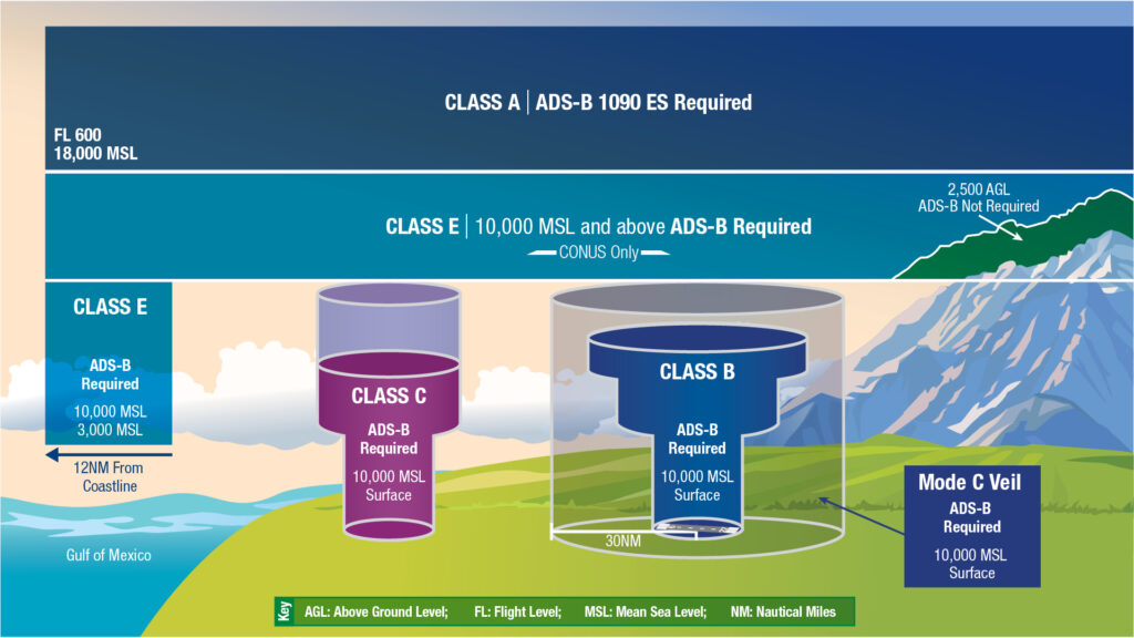
Commercial drone operations in the United States require FAA Part 107 certification. Beyond certification, any flight within controlled airspace requires authorization — either through the FAA's automated LAANC system or through a manual waiver process.
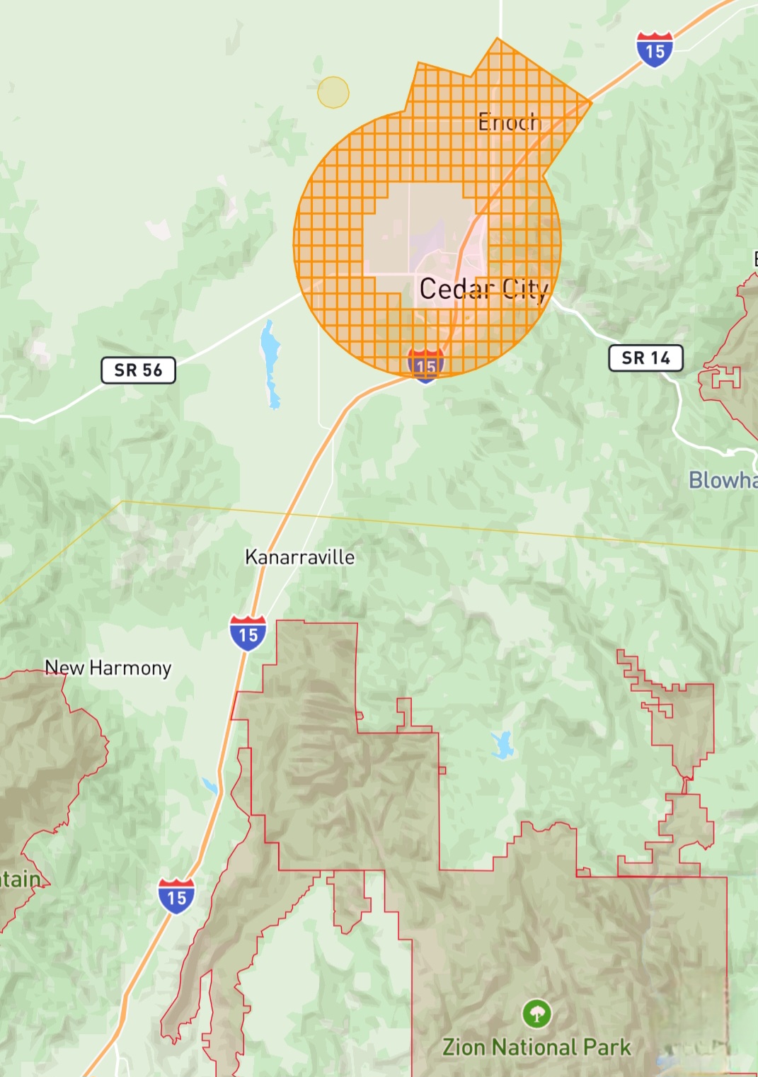
Cedar City Regional Airport (CDC)
Cedar City Regional Airport generates Class D controlled airspace extending around the airport. Cedar City's construction market is concentrated in areas that bring active job sites into proximity with CDC's airspace. A professional drone pilot will check airspace boundaries against the specific site coordinates before every engagement, obtain LAANC authorization where required, and carry documentation of that authorization on site.
This isn't a formality. Flying in Class D airspace without authorization is an FAA violation with real consequences — fines, certificate action, and potential project shutdown.
St. George Regional Airport (SGU)
St. George Regional Airport creates similar Class D restrictions across a significant portion of Washington County's development corridor — one of the most active real estate and construction markets in the state. For drone operators working across the St. George metro, LAANC authorization is a recurring operational reality, not an occasional edge case.
Temporary Flight Restrictions (TFRs)
TFRs are issued by the FAA on short notice for wildfire suppression operations, VIP movements, military exercises, and special events. Southern Utah experiences all of these on a regular basis.
Wildfire Season
Summer wildfire activity in Southern Utah is not hypothetical. The region's dry terrain, high winds, and seasonal heat create conditions that generate active wildfires — and active TFRs — with significant frequency between June and October. When aerial firefighting resources are working, TFRs ground all drone operations in the affected area, often with little or no advance notice.
For projects with tight documentation schedules, this is a genuine planning variable. A professional pilot will check TFR status before every flight, communicate proactively if a TFR affects a scheduled shoot, and reschedule promptly rather than attempt to fly in restricted airspace.
Military Operations
Portions of southern Utah fall within or near military operations areas and warning areas associated with training activity at nearby military installations. Pilots working in more remote areas of the region need to verify whether any military airspace affects their planned flight corridor.
Terrain, Wind & Heat
Airspace regulations are one layer of complexity. Southern Utah's physical environment adds another — and experienced pilots plan around it on every job.
Wind
The region's canyon terrain and mesa geography generate unpredictable, localized wind conditions — particularly in the afternoon hours. Thermal activity off exposed rock surfaces can create turbulence that affects both flight stability and image quality. Experienced pilots schedule flights in the early morning, when wind conditions are most predictable and consistent across the site.
Heat
Summer temperatures in the St. George area routinely exceed 100°F. Extreme heat increases battery discharge rates and can cause electronics to overheat during extended operations, compressing the usable flight window significantly in midsummer. A professional operator accounts for heat in flight planning — scheduling earlier and packing additional batteries.
Terrain Elevation Changes
Drone altitude above mean sea level is not the same as altitude above ground level (AGL), and the FAA's 400-foot AGL ceiling applies to the ground directly below the aircraft at any point in the flight — not just the launch point. Maintaining proper AGL across changing terrain requires active management. Pilots who don't account for terrain change risk both regulatory violations and collision with rising terrain.
Insurance & Certification: The Baseline
Before any commercial drone operation on a job site, two documents should be in hand: proof of FAA Part 107 certification and a current certificate of insurance (COI).
An uncertified operator flying commercially is violating federal law — and any liability from an incident falls directly on the property owner and GC who hired them. Professional operators working near active construction carry on-demand commercial policies with the ability to generate a same-day COI, meeting the requirements of most GCs and site owners before the first flight.
Ask for both before any work begins. A professional operator produces them without hesitation. An operator who can't should not be on your job site.
YOUR DUE DILIGENCEHiring a Drone Pilot in Southern Utah
When evaluating drone services for a Southern Utah construction or land project, ask every candidate these questions:
- Are you FAA Part 107 certified? Can I see your certificate?
- Do you carry commercial liability insurance? Can you produce a COI before the flight?
- How do you check and manage airspace for each project, including LAANC authorization?
- Have you flown in this area before? Do you understand the local airspace and terrain?
- What is your process if a TFR or weather event cancels a scheduled flight?
A pilot who can answer all of these clearly and specifically is operating professionally. Vague answers to any of them are a signal to look elsewhere.
Questions About Drone Airspace or Your Next Project?
Tom at BlueCrest Aerial is a FAA Part 107 certified drone pilot based in Cedar City, Utah, with direct experience navigating Southern Utah's airspace, terrain, and regulatory environment for construction and land development clients. BlueCrest Aerial carries commercial liability insurance with same-day COI capability and operates RTK-capable equipment for construction documentation and mapping projects.
GET A QUOTE TODAY bluecrestaerial.com