If you are a General Contractor or site manager running a heavy civil or commercial project, you already know that bad data is worse than no data at all. When you are managing moving iron, organizing massive concrete pours, and trying to keep stakeholders off your back, you need accurate, reliable site documentation. Drone mapping has become the standard for getting that data — whether you are calculating cut and fill volumes or tracking progress week over week.
But one question keeps coming up when GCs sit down to coordinate these flights: What is the best time of day to schedule drone site photography?
Here is the short answer: the best time to fly is whenever you need it done. If the project demands a flight at sunrise before the crews get out of their trucks, the drone goes up at sunrise. If you need a late evening shot after the dust settles, that is exactly what you will get. But if you want the full technical picture — how timing actually impacts your data, your orthomosaic maps, and your project schedule — there is a lot more to the story.
The Reality of Job Site Scheduling: The Client Writes the Check
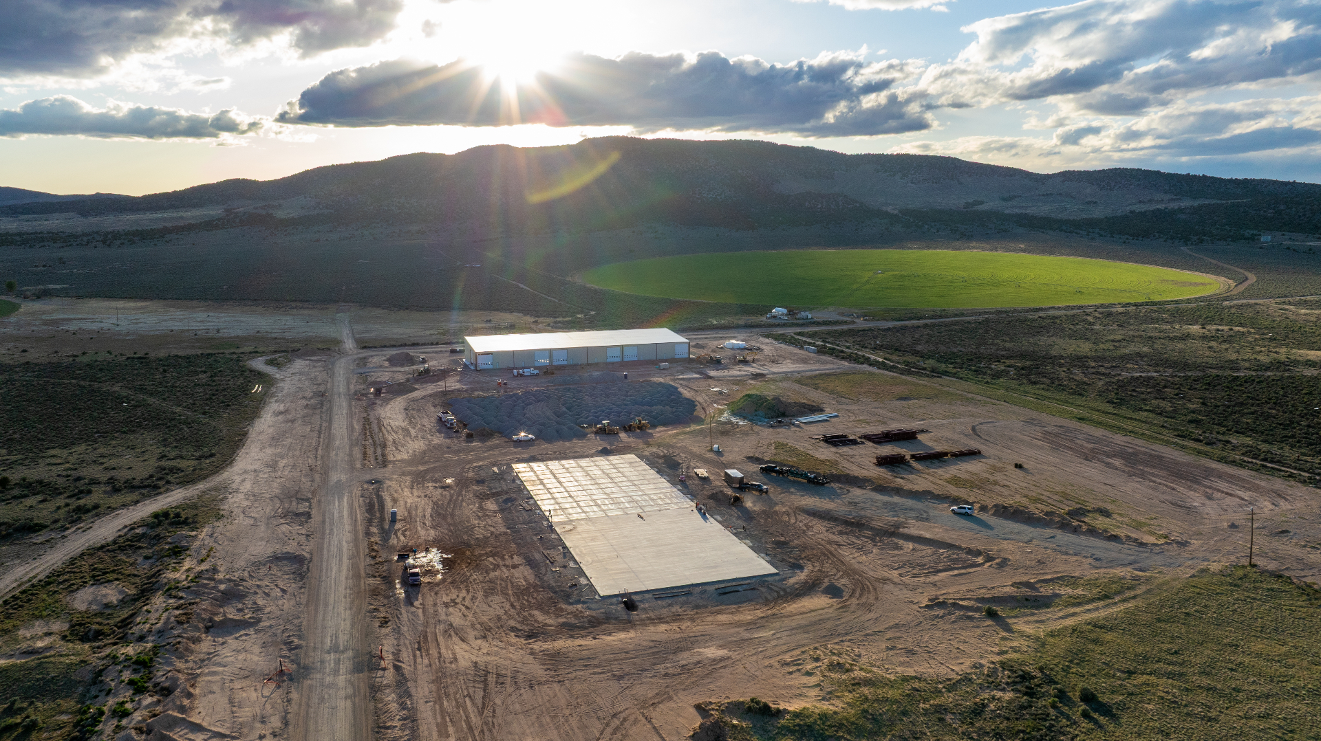
In a perfect, textbook scenario, drone mapping professionals love to fly at high noon or under a completely flat, overcast sky. Why? Because it eliminates harsh shadows. When you are pulling an orthomosaic map of a massive earthwork site or a complex concrete foundation, shadows can obscure details in deep trenches or hide the edges of formwork.
But out here in the real world, the textbook goes out the window. The client writes the check, and the project schedule dictates the reality of the day.
If a GC wants an early morning flight because that is the only window that makes sense for daily operations, that is what they are going to get. If they want a late evening flight to wrap up the week, the drone is going in the air at dusk. A professional operator knows how to adjust flight parameters, camera settings, and image overlap to compensate for the sun's angle — regardless of when the shot needs to happen.
When you fly early or late, long shadows are part of the deal. This is where Ground Control Points (GCPs) come into play. By placing highly accurate, measured targets across the site, we lock the drone's visual data to real physical coordinates on the ground. That guarantees high-precision RTK/PPK accuracy on your cut and fill math — even when the lighting isn't perfect.
Moving Iron: Do We Need to Shut Down the Site?
When scheduling a flight, a lot of project managers assume the site needs to be completely dead for the drone to do its job. There is a persistent idea that you have to park every excavator, shut down the scrapers, and halt the concrete trucks just so the drone can take a picture.
Let's clear that up right now: you absolutely do not need to stop working.
A map looks cleaner when everything is parked and the site is still — if you want a pristine, empty site for a marketing brochure, scheduling a Sunday morning or late-evening flight after crews go home is the right call. But for practical, day-to-day data collection? Moving equipment does not break the map.
Photogrammetry software analyzes hundreds — sometimes thousands — of overlapping high-resolution photos to build your orthomosaic. It calculates the stationary ground beneath moving equipment and stitches the map together without warping the actual topography.
When we generate an orthomosaic map, the software is analyzing those hundreds of overlapping photos and stitching them into one massive, accurate top-down view of the project. If a dozer is pushing dirt or an excavator is swinging its boom while the drone is overhead, the software handles the movement. It locks onto the stationary ground beneath the equipment and builds the map without warping your topography.
The primary goal is your cut and fill numbers, your grade verification, your rebar and footing layout. The math still works flawlessly with an active crew on the ground. We fly at a safe altitude, stay out of your way, and let your guys do what they do best while we capture the site from above.
Calendar Schedules vs. Milestone Mapping: The Hybrid Approach
When site managers sit down to figure out when to bring the drone out, they usually fall into one of two camps: rigid calendar scheduling or milestone-based scheduling. The most efficient approach is a hybrid of both.
The Weekly Calendar Flight
A set schedule — every Friday afternoon, for example — is the easiest way to keep remote stakeholders, owners, and investors off the PM's back. When the front office knows a fresh orthomosaic map is hitting their inbox at the end of every week, they stop calling the trailer asking for updates. It builds a consistent visual timeline from the day the first scraper hits the dirt to the day final landscaping goes in.
Milestone Mapping
While weekly updates are great for progress tracking, milestone flights are where the heavy technical data comes into play. You don't want a drone in the air just because it's Friday — you want a drone in the air because you just bottomed out a massive excavation and need to verify volume before backfilling. You want an orthomosaic map generated the day before a multi-thousand-yard concrete pour to verify that all the formwork, plumbing sleeves, and post-tension cables are exactly where they need to be.
By combining a regular weekly flight with specific, on-demand flights tied to your biggest project milestones, you always have high-precision RTK/PPK accuracy on your most critical phases — while still maintaining that consistent timeline for the executives upstairs.
Weather Constraints: When Does the Bird Actually Get Grounded?
A common question from managers planning their schedules is how much the weather or the season actually dictates flight times. Do you need to fly at the crack of dawn in the middle of summer just to keep the drone batteries from overheating?
The short answer is no. The heat, the cold, or the specific season does not fundamentally change how we schedule jobs.
Professional-grade drone equipment — the kind used to pull high-precision RTK/PPK accuracy on major infrastructure projects — is built to handle the elements. If you need a midday flight in the dead of summer, the drone performs. If you need a winter flight over a frozen site, the drone performs. You do not have to rearrange your job site schedule because of the temperature.
- Active storms: Heavy rain, active snowfall, or extreme sustained wind gusts that exceed the aircraft's safety ratings ground the drone. Water and high-end electronics don't mix, and fighting a gale-force wind destroys battery life and compromises the stability needed for a clean map.
- Complete darkness: Photogrammetry software requires daylight to capture clear visual data and stitch images together. You cannot map in the absolute dark.
- Overcast skies: These are actually ideal. Flat cloud cover kills harsh shadows and gives perfectly even light across the site — exactly what you want for clean orthomosaic data.
Outside of active storms and nightfall, the weather is just another condition we work through. Your schedule stays the priority.
Data Delivery and the 12-Hour Rush Charge
Scheduling the flight is only half the equation. The other half is getting the data back into your hands so you can actually use it. You can schedule the most perfectly timed flight in the world, but if it takes a week to process, it is useless to a site manager who needs to make decisions today.
Processing high-resolution 3D meshes and rendering a massive orthomosaic map takes serious computing power. We are talking about crunching gigabytes of visual data to ensure every pixel aligns perfectly with the ground control points and maintains strict high-precision RTK/PPK accuracy.
Because of this, standard turnaround runs 24 to 48 hours depending on the size of the site and the complexity of the deliverables. This gives the software the time it needs to render the models and allows for quality control checks on the cut and fill math before it lands in your hands.
Need it faster? If you schedule a late evening flight and need that orthomosaic map loaded onto your tablet for a 7:00 AM subcontractor meeting the very next morning, we can make it happen. But processing a massive dataset within a 12-hour window means jumping the queue, running the hardware at maximum capacity, and pulling late hours. Any delivery required within a 12-hour window carries a rush charge. When that data prevents a costly mistake during a morning pour, that charge pays for itself tenfold.
Flexibility Is the Ultimate Tool
At the end of the day, the best time to schedule drone site photography isn't dictated by shadows or the season — it is dictated by the needs of your specific project.
Whether you are pushing dirt and need cut and fill volumes, or you are laying out a massive commercial foundation and need to verify your formwork, the goal is always the same: highly reliable data with high-precision RTK/PPK accuracy, delivered when you need it.
If you want a perfectly clean map, we can schedule around the crews. If you can't afford to stop moving iron for even a minute, we fly right over the top and the software handles the rest. You build the schedule — we put the bird in the air, hit the control points, and deliver the orthomosaic map you need to keep your site running.