On any commercial jobsite, a General Contractor or Project Manager is constantly balancing two massive, competing pressures: keeping the project on schedule and ensuring every guy on site goes home safe at the end of the day.
It's a brutal balancing act. A single major safety incident doesn't just devastate a family — it triggers an avalanche of logistical nightmares. The site shuts down. OSHA rolls in with clipboards and fines. Timelines tank, liquidated damages start ticking, and your subcontractors get scattered. In commercial construction, safety isn't a separate line item — it is the foundation of operational momentum.
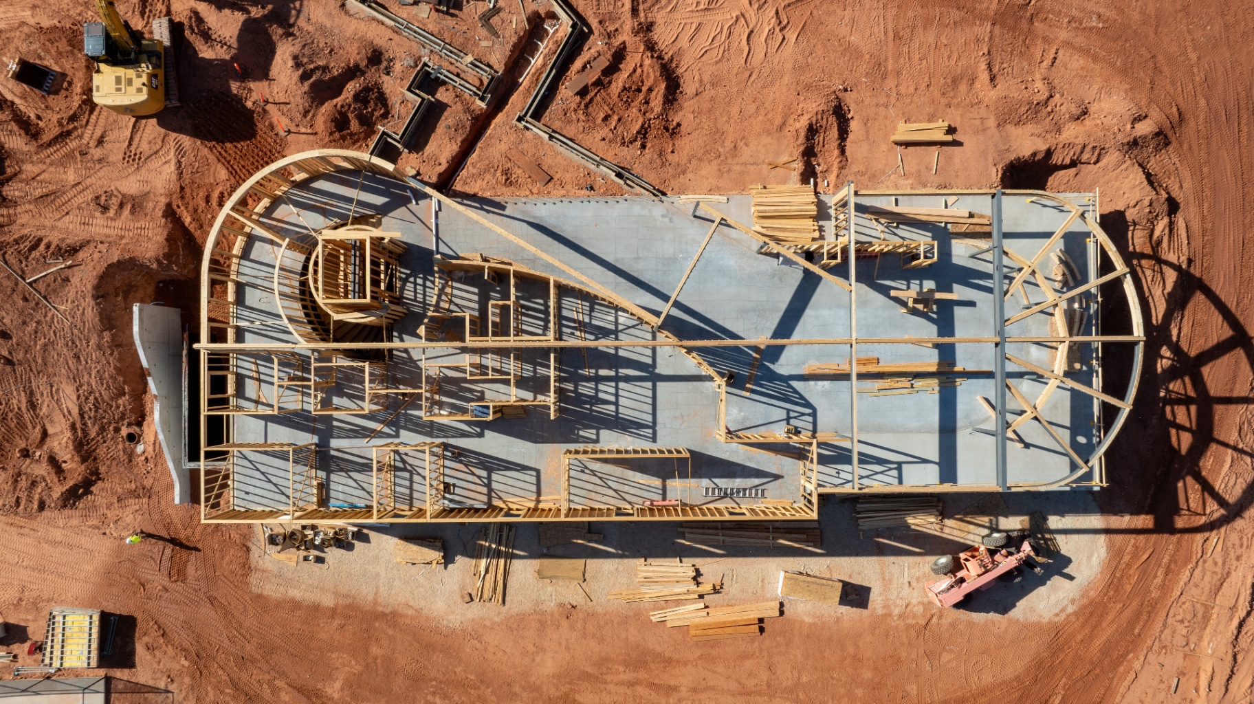
But managing a fast-moving, multi-million-dollar site from a gravel parking lot or a job trailer is like trying to coach a football game from the locker room. You are dealing with limited visibility, delayed data, and blind spots the size of a concrete mixer.
That is where aerial intelligence comes in. Forward-thinking GCs are realizing that drones aren't just toys for marketing videos or pretty pictures for the client's website. When deployed correctly, a drone is a high-yield operational tool that gives managers total site situational awareness.
Here is a gritty, realistic look at how commercial drones are changing the game, eliminating hazards, and keeping projects moving.
1. Eliminating the "Boots-on-the-Ground" Risk in High-Hazard Zones
The easiest way to prevent a workplace injury is simple: don't put a human being in a hazardous position in the first place.
Traditionally, inspecting high-elevation structures, deep excavations, or complex forms meant sending a worker directly into harm's way. Drones rewrite that playbook by replacing human exposure with digital data collection.
High-Elevation and Structural Framing Inspections
Consider the risk involved in inspecting structural steel framing, massive roof assemblies, or large-scale vertical infrastructure like municipal water tanks. Traditionally, checking a weld, inspecting a connection, or verifying a roof decking installation required scaffolding, manlifts, or rope-access teams. Every minute a worker spends suspended in a harness or riding a boom lift over uneven ground is a minute where a catastrophic fall can happen.
A drone equipped with a high-resolution, mechanical-shutter camera can capture crystal-clear, centimeter-level detail of a structural connection in a fraction of the time. The manager stays firmly on the ground, looking at a high-definition screen, while the aircraft handles the elevation risk.
Deep Excavations and Trench Safety
Foundation work and deep utility trenching are among the most unpredictable phases of a commercial build. Shifting soil weights, improper benching, and water mitigation issues can transform a trench into a death trap in seconds. Sending a superintendent or surveyor to stand at the edge of an unstable slope to check a grade or inspect a shoring wall is an unnecessary gamble.
By utilizing regular drone flights to generate accurate elevation models, a PM can monitor slope stability and verify trench geometry from the safety of the office. If a slope begins to deform or a trench wall shows signs of shifting, the data catches it before a worker ever steps foot inside the zone.
2. Managing the Chaos of Major Concrete Pours and Heavy Machinery Logistics
A commercial jobsite during a major foundation or deck pour is organized chaos. You have a constant rotation of concrete mixers backing in, pump trucks extended, rebar crews tying off the next section, and finishing machines idling. The sheer volume of moving parts creates an environment ripe for "struck-by" and "caught-in-between" incidents — two of OSHA's notorious "Fatal Four" safety hazards.
From the ground, a superintendent can only see what is directly in front of them. Their vision is blocked by stacks of material, heavy equipment, and outbuildings. They can't see that a delivery truck is backing up dangerously close to a crane's swing radius, or that a crew has staged material right in an emergency egress route.
An aerial viewpoint changes everything:
- Logistical Conflict Resolution: A quick drone flight creates a current, comprehensive snapshot of the entire layout. Managers can instantly spot pinch points where heavy equipment and foot traffic are forced into the same narrow corridors.
- Blind Spot Elimination: It allows GCs to optimize the site layout dynamically, ensuring that material staging areas, dumpsters, and concrete washout stations are positioned to minimize blind backing and chaotic equipment crossings.
- Housekeeping and Layout Audits: When multiple trades are stacked on top of each other, site layout standards can slip. Aerial maps clearly document blocked fire lanes, displaced perimeter fencing, or poorly managed material stockpiles that present safety hazards.
3. Replacing Hazardous Stockpile Surveys With Digital Volumetrics
Earthwork stockpiles — whether they are gravel, topsoil, or crushed concrete — are a staple of any commercial site. Tracking these volumes is critical for managing export costs and verifying material deliveries.
However, traditional inventory methods are inherently hazardous. They require a field technician to physically walk up and across loose, shifting mounds of aggregate with a GPS rover rod. One wrong step on an unstable crest can result in a severe slip, a rolled ankle, or a dangerous slide down a steep slope next to active heavy machinery.
Drones eliminate this field hazard entirely through photogrammetry:
How it works: A drone flies an automated grid pattern over the site, capturing hundreds of overlapping, geotagged photos. Specialized processing software uses these images to calculate millions of data points, creating a highly accurate 3D digital model of the earthwork. Instead of someone spending hours climbing dangerous piles, a drone can map a massive material yard in minutes — keeping human boots off the unstable slopes entirely.
4. The Digital Twin: Creating an Incontestable Safety Record
In the commercial world, an undocumented site is a liability nightmare. If an incident occurs, or if a subcontractor claims a site condition caused a costly delay or accident, it often turns into a game of "he-said, she-said."
By conducting regular, systematic drone mapping flights, a GC creates a continuous, undeniable historical record of the jobsite — a Digital Twin.
| Benefit | How It Works | Impact on Operations |
|---|---|---|
| OSHA Compliance Documentation | High-resolution orthomosaic maps prove that safety measures (like perimeter guardrails, trench shoring, and proper signage) were active on any given date. | Protects the GC from wrongful citations and provides immediate proof of compliance during inspections. |
| Site-Condition Documentation | Clear aerial photo trails show exactly the day-to-day conditions of the site layout and structural progress. | Eliminates disputes over who altered a site condition or left a hazard behind. |
| Proactive Hazard Auditing | Project managers can look back at weekly maps to spot troubling trends, like a slowly degrading haul road or a gradually encroaching material pile. | Allows managers to fix systemic site issues before they cause an actual accident. |
5. Debunking the Myth: Drones Aren't a Jobsite Distraction
Some old-school superintendents resist drone integration because they picture a loud, invasive hobbyist aircraft buzzing low over workers' heads, creating a massive distraction on an already stressful site.
That is not how professional construction drone operations work.
The reality of commercial drone integration is highly systematic and low-impact. In fact, actual drone flight time accounts for only about 10% of the entire job.
The vast majority of the work happens entirely out of sight and away from the active field:
- Pre-Flight Planning: The operator clears airspace permissions, checks weather conditions, and coordinates with site management before the props ever spin.
- High-Altitude, Automated Flight: The drone doesn't hover in workers' faces. It typically flies at a high, safe altitude — usually between 150 to 250 feet — using pre-programmed, automated flight paths. It moves predictably, quietly, and completely out of the way of cranes, rigging, and ground crews. It is in the air quickly, captures the data, and gets out.
- Off-Site Data Processing: The remaining 90% of the work takes place behind a computer screen. This involves processing the raw imagery, aligning data with ground control points, generating 3D models, and exporting clean orthomosaic maps that the project manager can access directly from a tablet or laptop.
The crews on the ground rarely have to look up, and the workflow on site never has to stop to accommodate the flight.
Conclusion: Building Faster by Building Safer
In commercial construction, speed and safety are often viewed as a trade-off. If you want to move faster, people assume you have to cut corners. If you want to be completely safe, people assume you have to slow down.
Aerial intelligence completely breaks that old paradigm. By providing GCs and project managers with accurate, bird's-eye data, drones allow construction teams to spot logistical bottlenecks, verify structural details, and manage site hazards long before they turn into accidents or schedule delays.
Investing in high-quality aerial data isn't just about avoiding an OSHA fine or getting a discount on your insurance premium. It's about running a tight, disciplined, professional jobsite where data drives the decisions, hazards are engineered out of the equation, and the project keeps moving forward smoothly.