If you've spent any time on a job site in Southern Utah, you know the drill. You've got schedules to meet, margins that are tighter than ever, and a lot of guys just trying to get through the day so they can get out of the heat. But there's a massive problem that almost every site out here deals with, and it's what I call the "Information Gap."
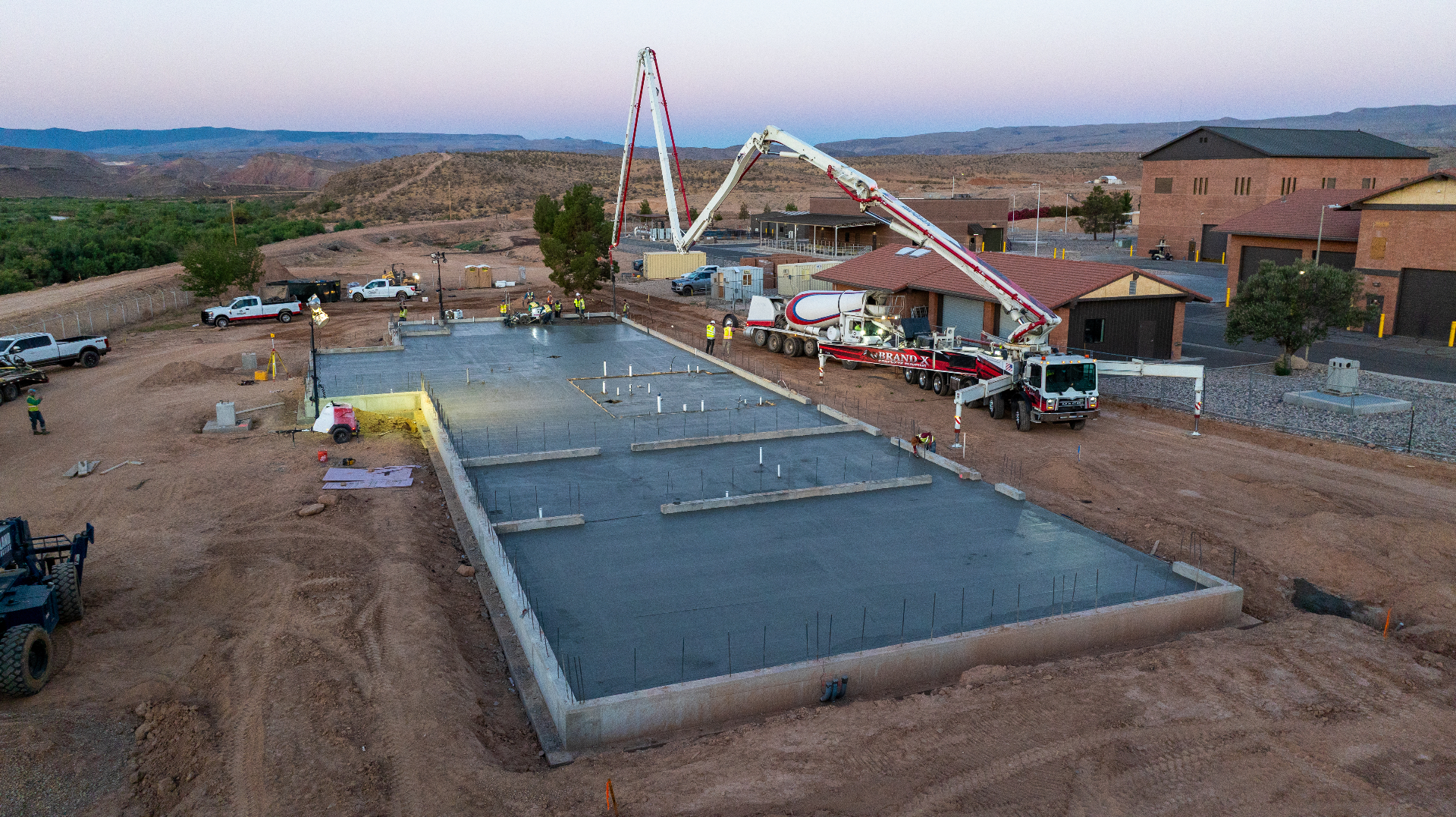
Most project management still happens with a clipboard, a tape measure, and a lot of guessing. We've all seen it: a dirt crew finishes up, says the grade is perfect, and moves their equipment out. Then the concrete guys show up, pull a string line, and realize the pad is six inches high in the back corner. Now you've got a crew of expensive guys standing around with shovels, digging out dirt by hand because nobody wanted to bring the skid steer back.
That's where drones come in. And I'm not talking about the guys who come out once a month to take a "pretty picture" for your Instagram. I'm talking about actual mapping that changes how a job is run.
1. Stopping the "Grade Gap" Before It Costs You
The biggest drain on a project's bank account isn't the price of fuel or materials — it's rework. In places like Washington County or over in Cedar, the dirt work is the foundation for everything. If that's off, everything else is a nightmare.
When a dirt crew "eyeballs" a grade, they're basically gambling with the concrete crew's time. I've seen footings that were supposed to be ready to pour, but because the grade was three inches low, the contractor had to eat the cost of all that extra concrete just to fill the hole. Or worse, it's too high, and you're paying guys $30 an hour to be human backhoes.
With a mapping drone, you fly the site the minute the dirt guys say they're done. You get a "heat map" that shows you exactly where the ground is high (red) or low (blue) compared to the blueprints. You catch that error on a Tuesday, call the dirt guys back Wednesday, and your concrete pour on Thursday goes perfectly. That's how you actually manage a project.
2. Processing Data at the Speed of the Job Site
One reason people haven't used drone maps much in the past is that the data took forever to get back. If you have to wait three days for a survey report, the site has already changed twice. It's useless.
But now, we're using high-end computers that can chew through hundreds of photos in a couple of hours. I can fly a site in the morning and have a 3D digital twin on the super's desk by lunch. When you can see the "as-built" reality of your site in near-real-time, you stop making decisions based on what you think is happening and start making them based on what's actually there.
3. Solving the "Stockpile Guessing Game"
Managing materials is a logistical disaster. You see these massive piles of gravel or fill dirt, and everyone just guesses how much is there. "Yeah, looks like 500 yards." Then you get the bill for 700 yards and wonder where the money went.
Drones take the guesswork out of volumetrics. By using 3D point clouds, we can measure a pile to within 99% accuracy. You know exactly how much dirt you've moved, how much you need to import, and exactly what you should be billed for. If you're a General Contractor, this is your best friend for verifying subcontractor invoices. If the drone says they moved 400 yards, and they bill for 600, you've got the proof to back up your checkbook.
4. Digital Records: Covering Your Tail
We live in a world where everyone wants to point fingers when something goes wrong. Drones provide a "single source of truth."
Think about underground utilities. Once you bury those pipes and conduits under a slab, they're gone. If someone hits a line six months later, it's a guessing game where it actually was. But if you fly the site right before the pour, you have a high-resolution, GPS-accurate map of every pipe in the ground. You have a permanent digital record that protects you from liability and makes future maintenance ten times easier.
Once you pour over it, it's gone. A pre-pour flight takes under thirty minutes and gives you a GPS-accurate record of every buried utility and conduit on the site — permanently. That's the kind of documentation that protects you years down the road.
5. Accountability in a Rushed Market
Let's be honest: Southern Utah is booming, and a lot of companies are moving way too fast. When margins are tight and everyone is rushed, work gets sloppy. It's just the nature of the beast right now.
Drones act as a silent supervisor. When subcontractors know the site is being mapped every week, the "sloppiness" tends to disappear. You can't hide a missed grade or a poorly placed trench when there's a 3D model that anyone can look at from their phone. It forces a higher standard of work without the Project Manager having to spend four hours a day walking the site.
6. Remote Oversight for Out-of-State Owners
We're seeing a ton of developers from Salt Lake, Vegas, or California building out here. They can't be in St. George every day. Usually, they just get a phone call saying "everything is on track."
A drone map lets them "walk" the site from their office hundreds of miles away. They can see the progress on the 4-million-gallon water tank or the new treatment plant in Bloomington with their own eyes. It builds trust, reduces the need for constant travel, and keeps the project moving forward because everyone is looking at the same data.
Remote stakeholders don't need more phone calls. They need something they can actually see. A weekly aerial update replaces a dozen status emails with one image that tells the whole story.
7. Safety: Keeping Boots Off the Slopes
Construction is dangerous, especially when you're dealing with the steep terrain and canyon-side builds we have around here. Sending a guy with a GPS rover out onto a steep, loose embankment to take measurements is just asking for a claim.
A drone can do that same job in ten minutes without anyone ever putting a foot on a dangerous slope. You get better data, and your guys stay safe on the flat ground. In an industry where one bad accident can sink a company, the safety aspect of drone mapping is worth the investment alone.
8. Predicting the Monsoon: Drainage and Water Management
In Southern Utah, we don't get rain often, but when we do, it usually comes all at once. If your site isn't graded perfectly for drainage, a single afternoon monsoon can wash away thousands of dollars in subgrade prep and leave you with a massive pond where your foundation is supposed to go.
By using the elevation data from a drone map, you can run drainage simulations before the storm hits. You can see exactly where water is going to pool and where it's going to run off. This lets you dig your temporary diversion ditches or adjust your slopes before the mud becomes a problem. It's a lot cheaper to move dry dirt than it is to pump out a flooded site and start over.
9. Streamlining the Logistics Chain
Think about the sheer amount of time wasted on a site just waiting. Waiting for the gravel truck to show up, waiting for the inspector to see the trenches, or waiting for the surveyor to restake a corner.
When you have a highly accurate digital map, you can plan your logistics to the minute. You can show a delivery driver exactly where to drop a load of rebar so it's not in the way of the concrete trucks next week. You can give an inspector a 3D view of the site before they even leave their office. It turns the chaos of a job site into a streamlined operation where everyone knows exactly what is happening and where.
10. The Bottom Line: Moving the Needle
At the end of the day, drone mapping isn't about having a cool gadget. It's about not wasting money. It's about making sure the dirt is right so the concrete is right, and making sure the concrete is right so the steel is right.
If you're still managing your Southern Utah job sites the way they did twenty years ago, you're leaving money on the table. In an environment where the dirt is tough and the margins are tougher, you need every advantage you can get. It's time to stop guessing on your grades and start knowing your numbers. If you want to run a tight ship, you need an eye in the sky.