There is a massive misconception in the construction industry that hiring a professional drone pilot means blowing up your project budget. You hear stories about guys charging thousands of dollars for highly produced marketing videos or massive, week-long survey missions, and it is easy to assume that aerial data is just a luxury for the mega-contractors.
Out here in the real dirt, concrete, and steel — that isn't the case at all.
For general contractors, site managers, and earthwork crews dealing with tight margins, the biggest value often comes from fast, reliable, and repeatable data that costs less than a grand. If you are working with budget constraints, you don't need to spend a fortune to get eyes in the sky. In fact, some of the most critical data you can pull off a job site falls well under the $500 mark.
At BlueCrest Aerial, the goal isn't to sell you fluff or pretty pictures you don't need — it's about providing hard, actionable data that saves you time and headaches. Let's break down exactly what kind of professional drone services you can realistically get for under 500 bucks, the exact pricing structures to expect, and why trying to do it yourself with a cheap consumer drone is a massive trap.
The "I Can Just Fly It Myself" Trap (And the Law)
Before getting into the actual services, we have to talk about the elephant in the room. When project managers see a $250 or $475 price tag, the first thought is usually: "Why would I pay that? I can run down to Best Buy, grab a cheap drone for 400 bucks, and just have one of the guys fly it over the site."
On paper, that sounds like a great way to save money. In reality, it is a massive liability that can cost a company tens of thousands of dollars in fines, lawsuits, and wasted time.
The legal reality: The FAA does not play games with commercial drone operations. The second a drone leaves the ground to check a roof, monitor earthwork progress, or take photos for an owner's update, that flight legally crosses the line into commercial work. It doesn't matter if you aren't explicitly selling the photos — if the flight advances a business purpose, the operator must hold an active FAA Part 107 Commercial Drone License.
If an unlicensed superintendent flies a drone over a commercial job site and the FAA finds out, the fines are brutal. But the fines aren't even the scariest part — it's the liability. Job sites are dangerous enough with heavy machinery, concrete pours, and active framing. If an untrained operator crashes a drone into a piece of equipment, drops it on a worker, or causes property damage, standard general liability insurance is likely going to deny the claim the second they realize the flight was illegal and unlicensed.
Beyond the legal and insurance nightmares, there is the logistical headache. Airspace authorizations aren't always simple. If your site is near an airport, a hospital with a helipad, or controlled airspace, a certified pilot knows exactly how to get legal clearance through LAANC or direct FAA waivers. An untrained operator with a consumer drone will either get grounded by the software or fly illegally and risk federal charges.
Finally, a GC's time is simply worth more than trying to figure out drone technology. Your job is to keep the schedule tight, manage the subs, and make sure the materials show up on time. Paying a professional $250 to show up, handle the airspace, fly a consistent route, and hand over exactly the data you need is a massive net gain for your productivity.
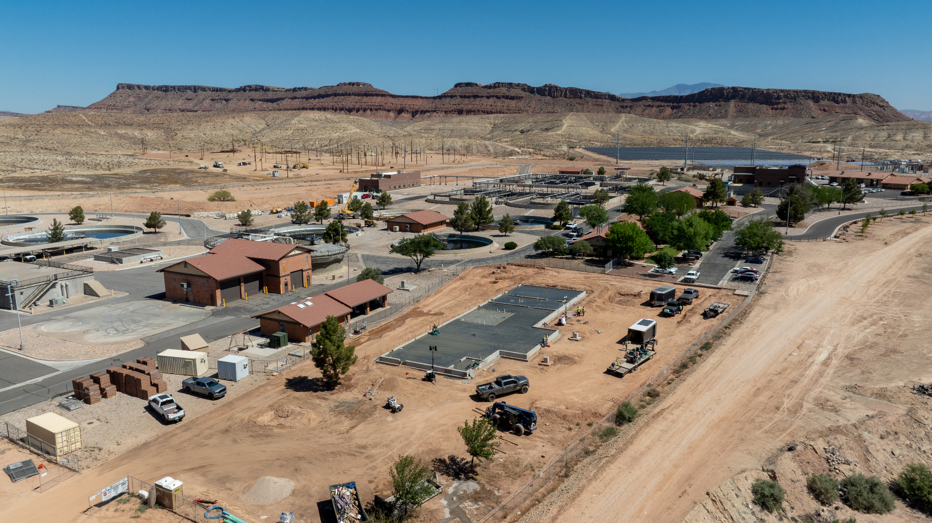
Site Progress Documentation: The $250 Sweet Spot
When it comes to high-value, low-cost drone services, basic site progress documentation is the undisputed king. For right around $250 per visit, a professional pilot can handle complete visual documentation of a standard commercial or large residential site.
What You Get for $250
Basic progress documentation isn't just someone flying around randomly snapping photos. A professional operation sets up a repeatable, automated flight path using GPS waypoints. Whether you are looking at the site on week one during initial grading, week four during foundation pours, or week twelve during framing — the camera is capturing the exact same angles, heights, and perspectives every single time.
This is incredibly valuable for site managers. It allows you to easily flip through a chronological timeline of the build. When an owner or stakeholder halfway across the country calls asking for an update, you don't have to walk the site with a cell phone trying to text blurry photos. You forward them the clean, high-resolution aerial portfolio. It keeps everyone on the same page, settles disputes with subcontractors about what work was completed on what date, and provides a permanent visual record of the entire project.
The Pricing Breakdown and Travel
At BlueCrest Aerial, the $250 baseline covers standard progress documentation within a 25-mile radius — covering the vast majority of local commercial builds without incurring extra costs.
Construction happens where the land is, and sometimes that means driving out of town. If a job site sits outside that 25-mile radius, standard travel fees kick in to cover fuel, vehicle wear, and drive time. You can generally expect this to run between $0.70 and $0.85 per mile outside the initial radius — a straightforward, transparent cost that keeps the base price low for local jobs while fairly compensating for the distance on remote sites.
Multi-Visit Discounts
Construction is a long-term game. Very rarely does a GC only need one single photo update. Because progress documentation is most effective when done weekly, bi-weekly, or monthly, there is usually room for budget optimization. If a project manager commits to more than five visits over the lifespan of a build, those per-visit rates often come down. Structuring a long-term documentation contract is the absolute best way to keep your data flowing while keeping your accounting department perfectly happy.
Budget-Friendly 3D Mapping & Earthwork Verification
Most people assume that 3D mapping and photogrammetry are strictly for massive topographical surveys costing thousands of dollars. While large-scale, high-precision mapping of major subdivisions does cost top dollar, there is a substantial market for small-scale, highly accurate mapping that falls comfortably under $500.
If you have a smaller site — say, a basic 1-to-2 acre commercial pad — you can absolutely get actionable 3D mapping data starting around $475. This range typically caps out around $850 depending entirely on the complexity of the job.
Volumetrics and Cut/Fill Data for Under $500
At the lower end of that pricing spectrum, around $475, you aren't paying for Hollywood-level 3D visual graphics — you are paying for raw, mathematical dirt data.
For earthwork contractors and GCs, managing dirt is one of the easiest places to lose money. Moving dirt is expensive, and hauling it off-site is even worse. A budget-friendly drone mapping mission can fly a 2-acre site and generate a highly accurate orthomosaic map alongside a relative 3D model.
The real value: volumetric scanning and cut/fill data. Without a drone, verifying how much dirt is in a stockpile requires a guy with a GPS rover walking up and down loose, shifting material — a genuinely dangerous task. A drone can fly that same stockpile in ten minutes and calculate the exact cubic yardage with strong accuracy. If you are trying to verify a subcontractor's pay app for the amount of dirt they claim to have moved, paying $475 for a cut/fill analysis gives you hard proof — potentially saving thousands on earthwork discrepancies.
When the Price Pushes Toward $850
What kicks a 1-to-2 acre mapping job from the $475 baseline up closer to the $850 mark? It all comes down to complexity, precision, and processing requirements.
- Terrain Complexity: Highly irregular terrain, dense vegetation, or obstructions require manual flying instead of automated grid patterns — increasing flight time and data collection significantly.
- Ground Control Points (GCPs): Engineering-grade accuracy tied to a specific local coordinate system requires placing and shooting GCPs with RTK GPS equipment on the ground, adding substantial on-site time and post-processing complexity.
- Processing Demands: Higher overlap requirements, finer resolution, and more complex 3D reconstruction push longer processing times on specialized photogrammetry software.
- Tight Airspace: Sites near airports, helipads, or controlled airspace require additional authorization steps and may limit automated operations, increasing planning time on the front end.
Even at the top end of this bracket, it is still significantly more affordable and faster than a traditional ground survey crew for the same site.
Setting Expectations: What's Not Included Under $500
Transparency is key when shopping for drone services on a budget. You need to know exactly what falls outside this tier so there are no surprises when the invoice arrives.
- Massive Acreage: You cannot map a 50-acre subdivision for $500. The flight time, battery management, and computer processing required for large datasets take hours, if not days. Sub-$500 mapping is strictly for smaller, 1-to-2 acre sites.
- Engineering-Grade Boundary Surveys: Drones provide incredible topographical data, but a drone pilot is not a licensed Professional Land Surveyor. If you need property boundary lines legally stamped and certified, you need a traditional survey crew. Drones are for site progress, volumetrics, and visual mapping.
- Heavy Video Editing: The $250 progress update tier is built for fast, clean, actionable data. A fully edited, color-graded marketing video with licensed music and motion graphics requires hours of post-production work that pushes well beyond the basic documentation price point.
By focusing on the data that actually matters — repeatable progress documentation and basic volumetric mapping — you can completely change how you manage a project for just a few hundred dollars a visit.