It's Not a Photography Business. It's an Auditing Firm.
You look at a quote for a mapping mission and think: "I'm not paying a few thousand bucks for a guy to play with a toy for an hour."
You're right to be skeptical. If it's just for photos, it is too expensive.
But a professional drone operation isn't a photography business — it's an auditing firm. When you hire a professional to map your site, you aren't paying for the flight. You're paying for the data verification that stops your subcontractors from "padding" their invoices and keeps your schedule from falling apart when a sub pulls off a job they haven't finished.
The 10% Rule: Why It's Not Just "An Hour of Work"
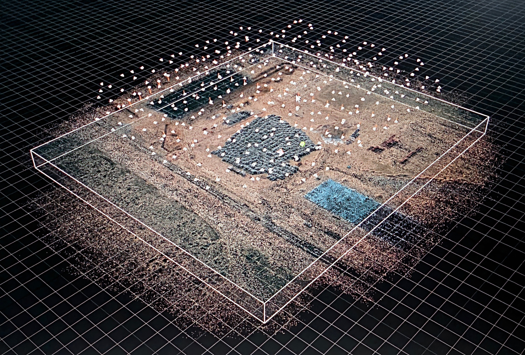
The biggest misconception is that the job happens in the air. In reality, flying is only about 10% of the job. The real work — the heavy lifting that justifies the invoice — happens on the ground before and after the props stop spinning.
To give a GC a report they can actually use, a professional handles the full picture — from planning the flight path so every inch of the site is captured with enough overlap to build a 3D model, to processing hundreds of raw images into a single georeferenced map, to calculating exact cubic yardages so you know whether you're being overbilled for earthwork. That's the work. The flight is just how we collect the data.
The Schedule-Killer: Catching the 6-Inch Mistake
In a perfect world, if a dirt company pulls off before the grade is right, they come back on their own dime. They screwed it up, they fix it. But "on their dime" doesn't cover the GC's lost time.
Imagine your grading sub thinks they've hit subgrade and pulls their equipment. Two days later, your paving sub shows up and finds the north corner is still six inches too high.
Even if the grading sub agrees to come back for free, they aren't there now. Your paving crew is sitting idle, charging standby time, and your entire critical path just shifted 48 hours.
A drone flight 24 hours before that sub leaves provides a "Topographical Truth." If the map shows they haven't hit grade, they don't move their equipment. You keep the schedule moving and avoid the blame game between trades.
The Earthwork "Fluff Factor"
Earthwork is often the most "creative" area for subcontractor billing. You'll hear about swell factors and truck counts that never seem to add up.
| Category | Drone Mapping | Traditional Methods |
|---|---|---|
| Earthwork Billing Accuracy | VERIFIED TO THE YARD | TRUST THE TRUCK COUNT |
| Grade Verification | SURVEY-GRADE DATA | EYE-BALLING & HOPE |
| Schedule Protection | CATCH IT BEFORE THEY LEAVE | FIND OUT WHEN IT'S TOO LATE |
| Dispute Documentation | TIMESTAMPED & DEFENSIBLE | HE SAID / SHE SAID |
| Overbilling Exposure | NEAR ZERO | SIGNIFICANT & UNVERIFIED |
| Typical Cost to the GC | KNOWN UP FRONT | UNKNOWN UNTIL IT'S TOO LATE |
Understanding the Investment
Because every job site is different — ranging from a 2-acre lot to a 100-acre subdivision — pricing isn't one-size-fits-all. Reach out and we'll put together a number specific to your site — no obligation, straight answer.
When a GC mentions that their "nephew has a drone" who can do it for $100, they're comparing a shovel to a backhoe. Professional mapping requires a serious tech stack — specialized software that stitches hundreds of photos into a single, massive, georeferenced image called an orthomosaic. The software doesn't just show you a picture; it builds a mathematical model of your project. If you want to understand exactly what you'd be getting, here's a full breakdown of our deliverables.
You are paying for the insurance that when a dispute goes to the owner or a lawyer, you have a certified paper trail that is impossible to argue with.
Stop Guessing. Start Verifying.
If you're managing a multi-million dollar project, you shouldn't be relying on truck tickets and eye-balling grades. The cost of a drone map isn't a fee for a flight — it's the cost of knowing exactly where your money is going. Reach out and we'll tell you straight whether it makes sense for your site.
The next time a sub says "the pile is gone" or "we're at grade," don't take their word for it. Verify it.